
pipeline
タグをコピペすると、ブログなどにカンタン貼り付けできます。
各画像のライセンスに従って利用してください。被写体の肖像権、商標・意匠登録等にご注意ください。
詳しくはクリエイティブ・コモンズ・ライセンスの利用についてをご覧ください。

Chandalar Shelf. The Pipeline Will Cross the River Here at the Bend before Descending the 700-Foot-High Bluff Into the Headwaters of the Dietrich River, Shown in the Upper Distance. This View Looks Southwest 08/1973
by U.S. National Archives
by U.S. National Archives
No known copyright restrictions(著作権制限なし)


> Delta Junction with Jarvis Creek Appearing in the Upper Distance. View Looks South. Pipeline Will Cross Jarvis Creek East (Left) of the Richardson Highway Which Links Fairbanks and Valdez 08/1973
by U.S. National Archives
by U.S. National Archives
No known copyright restrictions(著作権制限なし)


A View Northeast From Dietrich Pass Into the Headwaters of the Atigun River Valley...08/1973
by U.S. National Archives
by U.S. National Archives
No known copyright restrictions(著作権制限なし)


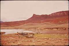
Looking East over Oil - Spill Clean - Up Operation Area in Monument Valley, Utah, 10/1972
by U.S. National Archives
by U.S. National Archives
No known copyright restrictions(著作権制限なし)


Persian Gulf Region and Bechtel Construction; about 1950
by David C. Foster
by David C. Foster


View North Toward Dietrich Pass From a Point Above the Northwest Tributary of the North Fork of the Chandalar River. The Road and Pipeline Will Run Up the Center of the Narrow Valley to the Pass (Mile 162) 08/1973
by U.S. National Archives
by U.S. National Archives
No known copyright restrictions(著作権制限なし)


Crossing the West Fork of the Gulkana River. View Southeast Here the Pipeline Crosses the Meandering Channels Diagonally Northeast to Southwest, From the Lower Left to the Upper Right of the Frame 08/1973
by U.S. National Archives
by U.S. National Archives
No known copyright restrictions(著作権制限なし)


starr-170520-8810-Psychotria_mariniana-habit_with_Forest-Road_to_Lower_Kula_Pipeline_Haiku_Uka-Maui
by Starr Environmental
by Starr Environmental

People Risk Arrest at State Department Office in Boston Protesting Keystone XL Pipeline
by NoKXL
by NoKXL


starr-170516-0209-Clidemia_hirta-habit-Lower_Kula_Pipeline_Haiku_Uka-Maui
by Starr Environmental
by Starr Environmental


The View West to Island Homes Subdivision North of Fairbanks on the Chena River. Any Oil Spillage at the Pipeline Crossing Six Miles Upstream From This Point Could Directly Affect These Homes. Near Mile 445 08/1973
by U.S. National Archives
by U.S. National Archives
No known copyright restrictions(著作権制限なし)


View Northeast over Hogan Hill Showing the High Interior Plateau between the Alaska and Chugach Mountain Ranges. in This View, the Pipeline Runs behind the Hill, Upper Left to Lower Right North to South 08/1973
by U.S. National Archives
by U.S. National Archives
No known copyright restrictions(著作権制限なし)

2,581件~2,640件 (全 10,713件)