
pipeline
タグをコピペすると、ブログなどにカンタン貼り付けできます。
各画像のライセンスに従って利用してください。被写体の肖像権、商標・意匠登録等にご注意ください。
詳しくはクリエイティブ・コモンズ・ライセンスの利用についてをご覧ください。

For Hudson Engineering Corp. at Carthage
by SMU Libraries Digital Collections
by SMU Libraries Digital Collections
No known copyright restrictions(著作権制限なし)


Governor of Florida Jeb Bush at VFW in Hudson, New Hampshire, July 8th, 2015 by Michael Vadon
by Michael Vadon
by Michael Vadon


Governor of Florida Jeb Bush at VFW in Hudson, New Hampshire, July 8th, 2015 by Michael Vadon
by Michael Vadon
by Michael Vadon


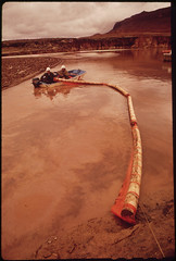
EPA Supervised Clean - Up of the San Juan River Oil Spill, 10/1972
by U.S. National Archives
by U.S. National Archives
No known copyright restrictions(著作権制限なし)


Governor of Florida Jeb Bush at VFW in Hudson, New Hampshire, July 8th, 2015 by Michael Vadon
by Michael Vadon
by Michael Vadon


Governor of Florida Jeb Bush at VFW in Hudson, New Hampshire, July 8th, 2015 by Michael Vadon
by Michael Vadon
by Michael Vadon

Governor of Florida Jeb Bush at VFW in Hudson, New Hampshire, July 8th, 2015 by Michael Vadon
by Michael Vadon
by Michael Vadon


Governor of Florida Jeb Bush at VFW in Hudson, New Hampshire, July 8th, 2015 by Michael Vadon
by Michael Vadon
by Michael Vadon

Governor of Florida Jeb Bush at VFW in Hudson, New Hampshire, July 8th, 2015 by Michael Vadon
by Michael Vadon
by Michael Vadon

Pipelines and Railroad Trestle over Vince's Bayou at N. Richey, Pasadena, Texas 0206101500BW
by Patrick Feller
by Patrick Feller


Governor of Florida Jeb Bush at VFW in Hudson, New Hampshire, July 8th, 2015 by Michael Vadon
by Michael Vadon
by Michael Vadon


Detail of the Marble House Newport Rhode Island. Built by a Vanderbilt as a wedding present for his wife.
by denisbin
by denisbin


Governor of Florida Jeb Bush at VFW in Hudson, New Hampshire, July 8th, 2015 by Michael Vadon
by Michael Vadon
by Michael Vadon

Governor of Florida Jeb Bush at VFW in Hudson, New Hampshire, July 8th, 2015 by Michael Vadon
by Michael Vadon
by Michael Vadon

Governor of Florida Jeb Bush at VFW in Hudson, New Hampshire, July 8th, 2015 by Michael Vadon
by Michael Vadon
by Michael Vadon

Governor of Florida Jeb Bush at VFW in Hudson, New Hampshire, July 8th, 2015 by Michael Vadon
by Michael Vadon
by Michael Vadon
Oil Slick on the San Juan River Just Above Log Boom...10/1972
by U.S. National Archives
by U.S. National Archives
No known copyright restrictions(著作権制限なし)


Colourful knitted pieces covering The Substation's building facade
by Jnzl's Photos
by Jnzl's Photos

Governor of Florida Jeb Bush at VFW in Hudson, New Hampshire, July 8th, 2015 by Michael Vadon
by Michael Vadon
by Michael Vadon

starr-170516-0167-Diplopterygium_pinnatum-frond-Lower_Kula_Pipeline_Haiku_Uka-Maui
by Starr Environmental
by Starr Environmental

Governor of Florida Jeb Bush at VFW in Hudson, New Hampshire, July 8th, 2015 by Michael Vadon
by Michael Vadon
by Michael Vadon


Caribou in "Alaska Cotton", a Plant Found in Marshy Areas Along Entire 789-Mile Route of the Alaska Pipeline 08/1973
by U.S. National Archives
by U.S. National Archives
No known copyright restrictions(著作権制限なし)


Governor of Florida Jeb Bush at VFW in Hudson, New Hampshire, July 8th, 2015 by Michael Vadon
by Michael Vadon
by Michael Vadon

Governor of Florida Jeb Bush at VFW in Hudson, New Hampshire, July 8th, 2015 by Michael Vadon
by Michael Vadon
by Michael Vadon

Governor of Florida Jeb Bush at VFW in Hudson, New Hampshire, July 8th, 2015 by Michael Vadon
by Michael Vadon
by Michael Vadon


Unloading Oil - Laden Debris from the San Juan River Onto Disposal Site in Monument Valley, Utah, 10/1972
by U.S. National Archives
by U.S. National Archives
No known copyright restrictions(著作権制限なし)

Governor of Florida Jeb Bush at VFW in Hudson, New Hampshire, July 8th, 2015 by Michael Vadon
by Michael Vadon
by Michael Vadon

Governor of Florida Jeb Bush at VFW in Hudson, New Hampshire, July 8th, 2015 by Michael Vadon
by Michael Vadon
by Michael Vadon

Governor of Florida Jeb Bush at VFW in Hudson, New Hampshire, July 8th, 2015 by Michael Vadon
by Michael Vadon
by Michael Vadon
2,641件~2,700件 (全 10,417件)