
cartographymanitobahistory
タグをコピペすると、ブログなどにカンタン貼り付けできます。
各画像のライセンスに従って利用してください。被写体の肖像権、商標・意匠登録等にご注意ください。
詳しくはクリエイティブ・コモンズ・ライセンスの利用についてをご覧ください。

Insurance Plan of the City of Portage La Prairie, Man. June 1959, 56 (1959)
by Historical Maps of Manitoba
by Historical Maps of Manitoba

Insurance Plan of the City of Portage La Prairie, Man. June 1959, 55 (1959)
by Historical Maps of Manitoba
by Historical Maps of Manitoba
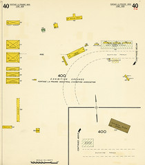
Insurance Plan of the City of Portage La Prairie, Man. June 1959, 40 (1959)
by Historical Maps of Manitoba
by Historical Maps of Manitoba

Insurance Plan of the City of Portage La Prairie, Man. June 1959, 39 (1959)
by Historical Maps of Manitoba
by Historical Maps of Manitoba
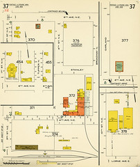
Insurance Plan of the City of Portage La Prairie, Man. June 1959, 37 (1959)
by Historical Maps of Manitoba
by Historical Maps of Manitoba

Insurance Plan of the City of Portage La Prairie, Man. June 1959, 26 (1959)
by Historical Maps of Manitoba
by Historical Maps of Manitoba

Insurance Plan of the City of Portage La Prairie, Man. June 1959, 25 (1959)
by Historical Maps of Manitoba
by Historical Maps of Manitoba

Insurance Plan of the City of Portage La Prairie, Man. June 1959, 24 (1959)
by Historical Maps of Manitoba
by Historical Maps of Manitoba

Insurance Plan of the City of Portage La Prairie, Man. June 1959, 23 (1959)
by Historical Maps of Manitoba
by Historical Maps of Manitoba

Insurance Plan of the City of Portage La Prairie, Man. June 1959, 17 (1959)
by Historical Maps of Manitoba
by Historical Maps of Manitoba

Insurance Plan of the City of Portage La Prairie, Man. June 1959, 16 (1959)
by Historical Maps of Manitoba
by Historical Maps of Manitoba
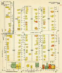
Insurance Plan of the City of Portage La Prairie, Man. June 1959, 14 (1959)
by Historical Maps of Manitoba
by Historical Maps of Manitoba

Insurance Plan of the City of Portage La Prairie, Man. June 1959, 13 (1959)
by Historical Maps of Manitoba
by Historical Maps of Manitoba

Insurance Plan of the City of Portage La Prairie, Man. June 1959, 12 (1959)
by Historical Maps of Manitoba
by Historical Maps of Manitoba

Insurance Plan of the City of Portage La Prairie, Man. June 1959, 11 (1959)
by Historical Maps of Manitoba
by Historical Maps of Manitoba

Insurance Plan of the City of Portage La Prairie, Man. June 1959, 10 (1959)
by Historical Maps of Manitoba
by Historical Maps of Manitoba

Insurance Plan of the City of Portage La Prairie, Man. June 1959, 9 (1959)
by Historical Maps of Manitoba
by Historical Maps of Manitoba

Insurance Plan of the City of Portage La Prairie, Man. June 1959, 8 (1959)
by Historical Maps of Manitoba
by Historical Maps of Manitoba

Insurance Plan of the City of Portage La Prairie, Man. June 1959, 7 (1959)
by Historical Maps of Manitoba
by Historical Maps of Manitoba

Insurance Plan of the City of Portage La Prairie, Man. June 1959, 6 (1959)
by Historical Maps of Manitoba
by Historical Maps of Manitoba

Insurance Plan of the City of Portage La Prairie, Man. June 1959, 5 (1959)
by Historical Maps of Manitoba
by Historical Maps of Manitoba

Insurance Plan of the City of Portage La Prairie, Man. June 1959, 4 (1959)
by Historical Maps of Manitoba
by Historical Maps of Manitoba

Insurance Plan of the City of Portage La Prairie, Man. June 1959, 2 (1959)
by Historical Maps of Manitoba
by Historical Maps of Manitoba

Insurance Plan of the City of Portage La Prairie, Man. June 1959, Standard Key of Signs (1959)
by Historical Maps of Manitoba
by Historical Maps of Manitoba

Insurance Plan of the City of Portage La Prairie, Man. June 1959, Key Plan (1959)
by Historical Maps of Manitoba
by Historical Maps of Manitoba

McPhillips Outline Map of Winnipeg & Vicinity (1909)
by Historical Maps of Manitoba
by Historical Maps of Manitoba


Hudson Bay Route Possible Port Terminal at Churchill (1927)
by Historical Maps of Manitoba
by Historical Maps of Manitoba

Hudson Bay Route Possible Port Terminal at Port Nelson (1927)
by Historical Maps of Manitoba
by Historical Maps of Manitoba

Hudson Bay Route Plan of Churchill Harbour (1927)
by Historical Maps of Manitoba
by Historical Maps of Manitoba

Hudson Bay Route Plan of the Nelson Estuary (1927)
by Historical Maps of Manitoba
by Historical Maps of Manitoba
![[Map Showing Chlorine, Hardness and Alkalinity of Ground Water North of Winnipeg] (1907)](http://farm3.static.flickr.com/2428/3750242574_5e227de985_m.jpg)
[Map Showing Chlorine, Hardness and Alkalinity of Ground Water North of Winnipeg] (1907)
by Historical Maps of Manitoba
by Historical Maps of Manitoba

General Plan Showing Routes for Pipe Lines from Winnipeg River and Shoal Lake (1907)
by Historical Maps of Manitoba
by Historical Maps of Manitoba

Plan Shewing Reservations for Railway Purposes and Town Plots (1877)
by Historical Maps of Manitoba
by Historical Maps of Manitoba

Design for Town and Village Plots at Stations on the Canadian Pacific Railway (1877)
by Historical Maps of Manitoba
by Historical Maps of Manitoba

Map of the Country to be Traversed by the Canadian Pacific Railway to Accompany progress Report on the Exploratory Surveys (1877)
by Historical Maps of Manitoba
by Historical Maps of Manitoba


International Boundary from the Gulf of Georgia to the Northwesternmost Point of the Lake of the Woods Sheet No. 59 (1927)
by Historical Maps of Manitoba
by Historical Maps of Manitoba

International Boundary from the Gulf of Georgia to the Northwesternmost Point of the Lake of the Woods Sheet No. 58 (1921)
by Historical Maps of Manitoba
by Historical Maps of Manitoba

International Boundary from the Gulf of Georgia to the Northwesternmost Point of the Lake of the Woods Sheet No. 57 (1921)
by Historical Maps of Manitoba
by Historical Maps of Manitoba

International Boundary from the Gulf of Georgia to the Northwesternmost Point of the Lake of the Woods Sheet No. 56 (1921)
by Historical Maps of Manitoba
by Historical Maps of Manitoba

International Boundary from the Gulf of Georgia to the Northwesternmost Point of the Lake of the Woods Sheet No. 55 (1921)
by Historical Maps of Manitoba
by Historical Maps of Manitoba

International Boundary from the Gulf of Georgia to the Northwesternmost Point of the Lake of the Woods Sheet No. 53 (1921)
by Historical Maps of Manitoba
by Historical Maps of Manitoba

International Boundary from the Gulf of Georgia to the Northwesternmost Point of the Lake of the Woods Sheet No. 52 (1922)
by Historical Maps of Manitoba
by Historical Maps of Manitoba

International Boundary from the Gulf of Georgia to the Northwesternmost Point of the Lake of the Woods Sheet No. 51 (1922)
by Historical Maps of Manitoba
by Historical Maps of Manitoba

International Boundary from the Gulf of Georgia to the Northwesternmost Point of the Lake of the Woods Sheet No. 50 (1922)
by Historical Maps of Manitoba
by Historical Maps of Manitoba

International Boundary from the Gulf of Georgia to the Northwesternmost Point of the Lake of the Woods Sheet No. 49 (1922)
by Historical Maps of Manitoba
by Historical Maps of Manitoba

International Boundary from the Gulf of Georgia to the Northwesternmost Point of the Lake of the Woods Sheet No. 48 (1922)
by Historical Maps of Manitoba
by Historical Maps of Manitoba

International Boundary from the Gulf of Georgia to the Northwesternmost Point of the Lake of the Woods Sheet No. 47 (1922)
by Historical Maps of Manitoba
by Historical Maps of Manitoba

International Boundary from the Gulf of Georgia to the Northwesternmost Point of the Lake of the Woods Sheet No. 46 (1922)
by Historical Maps of Manitoba
by Historical Maps of Manitoba
1件~60件 (全 457件)